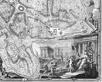
I was so excited to read the local paper that described a research project right here at my own University where a group of Architecture professors collaborated with cartographers and computer graphics specialist to product an online, interactive map of Rome based on the Nolli map of 1748.
"The 1748 Nolli map of Rome, regarded by scholars and cartographers as one of the most important historical documents of the city, serves to geo-reference a vast body of information to better understand the Eternal City and its key role in shaping Western Civilization. The Nolli Map Web Site introduces students to Rome and the structure of its urban form; it illustrates the evolution of the city over time; and it reveals diverse factors that determined its development. Above all the Nolli Web Site is intended to provide a vehicle for students and teachers around the world to explore and facilitate creative thought.
Background
Giambattista Nolli (1701-1756) was an architect and surveyor who lived in Rome and devoted his life to documenting the architectural and urban foundations of the city. The fruit of his labor, La Pianta Grande di Roma ("the great plan of Rome") is one of the most revealing and artistically designed urban plans of all time. The Nolli map is an ichnographic plan map of the city, as opposed to a bird?s eye perspective, which was the dominant cartographic representation style prevalent before his work. He was not only one of the first people to construct an ichnographic map of Rome, but his perspective has been copied ever since.
The map depicts the city in astonishing detail. Nolli accomplished this by using scientific surveying techniques, careful base drawings, and minutely prepared engravings. The map?s graphic representations include not only a precise architectural scale, but also a prominent compass rose, with both magnetic north and astronomical north carefully noted. The Nolli map is the first accurate map of Rome since antiquity and captures the city at the height of its cultural and artistic achievements. The historic center of Rome has changed little over the last 250 years; therefore, the Nolli map remains one of the best sources for understanding the contemporary city.
In the last half of the 20th century a renewed interest in the map by architects and urban designers has flourished and led to new urban theories that present a model for the study of all cities and their urban patterns. The intention of this website is to both reveal the historical significance of the map and the principles of urban form that may influence city design in the future.
Features of the Nolli Map
The Nolli map consists of twelve exquisitely engraved copper plates that measure approximately six feet high and seven feet wide when combined (176 cm by 208 cm). The map includes almost eight square miles of the densely built city as well as the surrounding terrain. It also identifies nearly two thousand sites of cultural significance. Nolli?s map is an extraordinary technical achievement that represents a milestone in the art and science of cartography. Modern surveys and sophisticated satellite images have confirmed the accuracy of Nolli?s map within the very smallest margin of error. The map not only records the streets, squares and public urban spaces of Rome, but Nolli carefully renders hundreds of building interiors by way of detailed plans. The detail of the map representation ensures the map's continuing value as a unique historical document, and it gives the viewer a glimpse into the ancient metropolitan center during one of its most illustrious periods.
Key Features of the Web Site
The website features a digitally mastered, high resolution interactive Nolli map, designed for broadband connections. The Map Engine may be accessed from any page of the website, allowing you to navigate through the city at a variety of scales. Using the Map Engine, the user can pan in any direction and zoom in or out from the macro-scale of the city to the micro-scale of the building. Layers have been created to focus on particular topics, for example " gardens.? The layers in this first edition will be updated and expanded to include many more topics. The topics that will be added include topographic and hydrographic information, specific building types, and census data by Rioni. Layers may be turned on and off, and blended with map below to provide for the best viewing conditions."
Check it out! http://nolli.uoregon.edu/default.asp
No comments:
Post a Comment